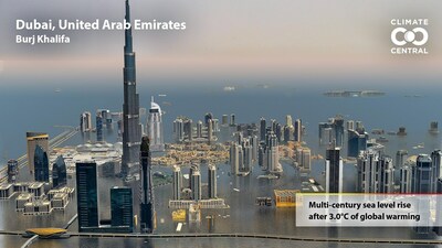
Landmark sites in COP 28 host Dubai are projected to remain above sea level if global warming stops at 1.5 degrees Celsius – but not at 3.0
PRINCETON, N.J., Nov. 30, 2023 /PRNewswire/ — New visualizations released today by Climate Central compare projected sea levels at iconic sites, based on different global warming scenarios. Localized analyses found that well-known areas of Dubai and other United Nations Climate Change Conference (COP) host cities, which are projected to remain above sea level if warming is halted at 1.5 Celsius degrees over pre-industrial temperatures, would fall below the high tide line if warming reaches 3.0 degrees.

COP 18 host Doha, Qatar (2012) and COP 20 host Lima, Peru (2014) show similar dependencies in Climate Central’s visualized analyses, with local landmarks remaining above sea level if global warming is limited, but falling below the high tide line if temperatures rise above set thresholds. Sites in Casablanca, Morocco and Jakarta, Indonesia – countries that have hosted past COPs – also show diverging futures based on global temperatures. Visualizations for these cities are now available in Climate Central’s Picturing Our Future digital library.
“Decisions made at COP 28 will shape the long-term future of Earth’s coastal cities, including Dubai,” Dr. Benjamin Strauss, Climate Central CEO and chief scientist said. “The survival of these places and their heritage will depend on whether government and industry leaders can agree to cut carbon pollution sharply enough and fast enough to limit global warming to 1.5 Celsius degrees.”
Other U.N. Climate Change Conference host cities featured in Picturing Our Future include: Glasgow, Scotland (2021); Durban, South Africa (2011); Copenhagen, Denmark (2009); The Hague, Netherlands (2000), and Buenos Aires (1998). Comparisons of more than 100 sites in 40 countries across multiple warming scenarios are freely available for media, educational, and non-commercial use at: picturing.climatecentral.org.
Analyses beneath Picturing Our Future visualizations are based on peer-reviewed sea level rise projections and localized land heights from Climate Central’s digital elevation model, CoastalDEM. While sea levels associated with different levels of sustained warming can be projected with relative confidence, the time it may take for seas to reach those levels depends on an array of complex factors. The sea levels visualized in Picturing Our Future are likely centuries away. The methodology is detailed in the peer-reviewed paper, “Unprecedented Threats to Cities from Multi-century Sea Level Rise,” published in 2021 in Environmental Research Letters.
This methodology also supports localized maps from Climate Central comparing future coastlines based on different global warming scenarios, available at: https://coastal.climatecentral.org/map/?theme=warming&map_type=multicentury_slr_comparison
Contact: Peter Girard, vice president of communications, Climate Central: pgirard@climatecentral.org or 609-986-1999
About Climate Central
Climate Central is a non-advocacy, non-profit science and news organization providing authoritative information to help the public and policymakers make sound decisions about climate and energy.

SOURCE Climate Central


