WHAT WAS CLAIMED
Greenland’s largest glacier has grown by more than 10km since 2012.
OUR VERDICT
Misleading. The glacier’s end point advanced after two massive icebergs detached. More broadly, the glacier and Greenland's ice sheet are retreating.
AAP FACTCHECK - A large glacier in Greenland has grown over the last 12 years contrary to what climate scientists have predicted, social media posts are claiming.
This is misleading. The glacier's edge has moved forward again in recent years, but only after massive "calving" events which shortened the glacier.
Overall, the glacier is in retreat, as is Greenland's entire ice sheet, which covers the majority of the island.
Glaciers are an important measure of climate change, according to the US Environmental Protection Agency.
The agency's website states that "if glaciers lose more ice than they can accumulate through new snowfall, they ultimately add more water to the oceans, leading to a rise in sea level."
One Facebook post claims: "The largest glacier in Greenland has grown by more than 10km since 2012, the year when climate-alarm scientists predicted the glacier would melt".
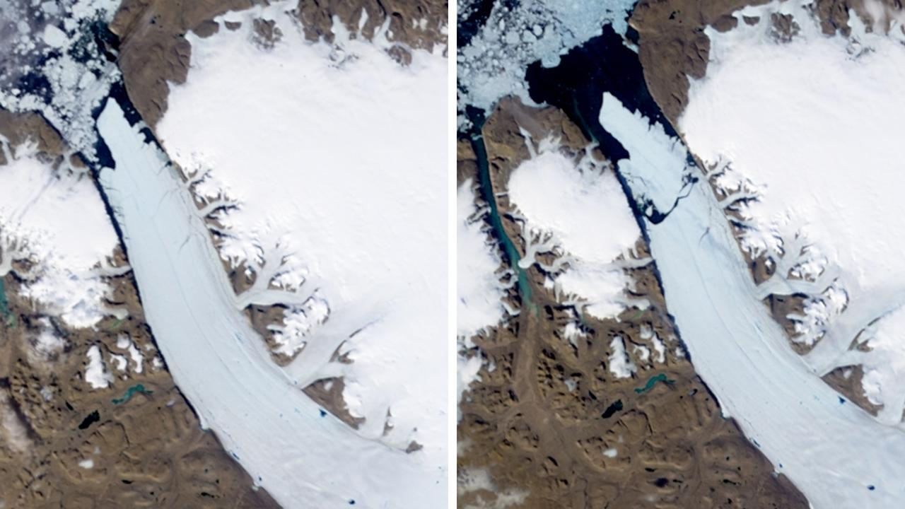
The post includes an image of the Petermann Glacier, a large glacier located on the island's northwest coast.
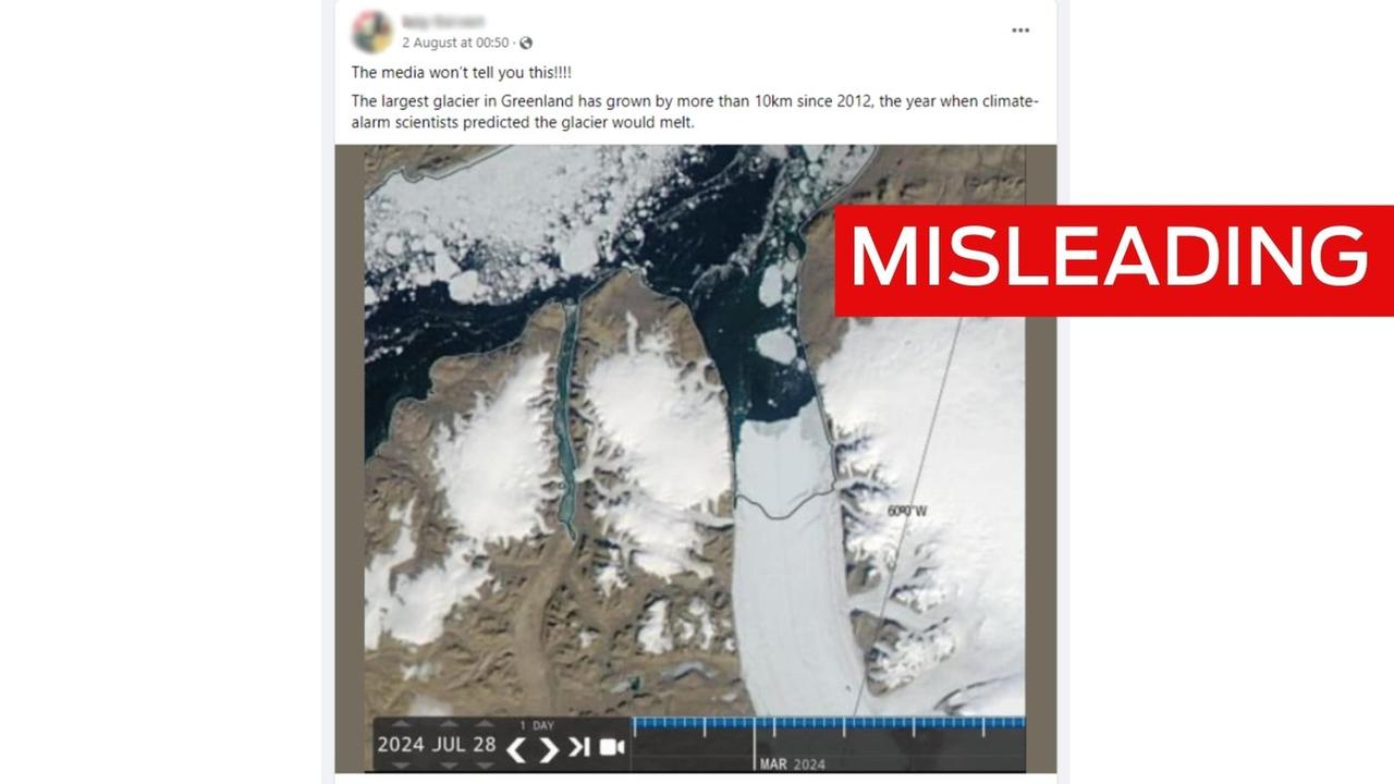
Despite what the post says, it's not the largest glacier in Greenland, but it is the longest floating glacier in the Northern Hemisphere according to the US Geological Survey.
The post, which has been shared thousands of times, goes on to say, "The media won't tell you this!!!!" and includes an aerial image of the glacier dated July 28, 2024.
However, experts said the post's use of the glacier's 2012 edge, or terminus, was missing important context.
The post also fails to look past the glacier's terminus. Glaciologists say it's important to measure the ice lost where glaciers connect to the ground underneath the water.
Glaciology professor Bethan Davies at Newcastle University told AAP FactCheck the post is a classic case of cherry-picking.
She said massive chunks of ice broke off from the glacier - 251 square kilometres in 2010 and 32 square km in 2012.
These "calving" events meant the glacier's terminus was reduced significantly.
"So picking a satellite image from before or after that [2012] calving event would give you a very different result," Prof Davies explained.
She said the terminus has since readvanced, though the 2019 level was still about 24km inland of the 2010 level, citing a 2022 study on Greenland glaciers.
Professor Eric Rignot is a leading glaciers expert at the University of California, Irvine.
He told AAP FactCheck that although the Petermann ice front had advanced in the last ten years following the massive calving events, the glacier front was "still in a state of retreat over the last century".
He also said the post ignores what's called the "grounding line", which is the point where the glacier body connects with the bedrock.
It shows how much ice is connected to the land and how much is floating in the ocean. This can be used to determine how much the melted ice causes the sea level to rise.
"If the floating ice advances or retreats, it does not matter, it has already displaced sea level when it crossed the grounding line".
Prof Rignot said the Petermann grounding line was relatively stable between 1996 and 2015, but has since retreated.
He pointed to a 2022 study that found the grounding line of the glacier's central area had retreated 7km from its 1992 position, the majority of which occurred from 2017 onwards, which he said was "unprecedented".
"The glacier is thinning. The cause is the presence of warmer ocean waters in the fjord," he added.
Prof Davies also said it's important to consider the bigger picture of the Greenland Ice Sheet.
She pointed to a 2021 study that collected over 20 years of satellite data from ice regions, which found the Greenland Ice Sheet lost around 3,902 gigatonnes of ice between 1992 and 2018.
Just one gigatonne is one billion metric tons, which, according to NASA, is equivalent to 10,000 fully packed U.S. aircraft carriers.
"Greenland's mass loss is largely through increased meltwater runoff and increased glacier discharge (increased glacier flow), leading to widespread thinning at the ice sheet margins," Prof Davies said.
NASA research has consistently found the Greenland Ice Sheet is losing mass, causing sea levels to rise.
AAP FactCheck has debunked similar claims before about ice sheets in Greenland and Antarctica.
The Verdict
Misleading – The claim is accurate in parts but information has also been presented incorrectly, out of context or omitted.
AAP FactCheck is an accredited member of the International Fact-Checking Network. To keep up with our latest fact checks, follow us on Facebook, Twitter and Instagram.